
Fast Facts:
- A storm stretching nearly 1,500 miles across the Pacific Coast is soaking California, threatening burn-scar areas with flash flooding, debris flows and mudslides.
- Evacuation orders have been issued for burn-scar zones that were scorched by January wildfires in Los Angeles.
- Elevations above 7,000 feet will see feet of snow, while the Pacific Northwest will see a dangerous ice storm.
LOS ANGELES – Over 22 million Californians are under flood alerts as torrential rain and mountain snow intensified over the state, part of an atmospheric river event that covers much of the Pacific Coast.
The significant risk of flooding and landslides in areas recently affected by devastating wildfires around Los Angeles triggered evacuations for those living near burn scars.
The event has already dumped heavy rains in Northern California, where Flood Advisories were issued around San Francisco.
Further south, a Flash Flood Warning was issued for the Palisades Fire burn scar on Thursday afternoon, according to the National Weather Service that services the Los Angeles metro.
The string of moisture even brought severe thunderstorms to the City of Angels with wind gusts in excess of 60 mph and the possibility of hail on Thursday evening.
According to the FOX Forecast Center, it has been nearly a year since the region had been under a Severe Thunderstorm Warning, as storms generally worked from northwest to southeast across the region.
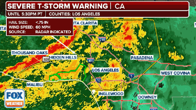
Severe Thunderstorm Warning in Los Angeles County.
(FOX Weather)
WEEKEND WINTER STORM TO BRING HEAVY SNOW TO NORTHEAST, SEVERE WEATHER TO SOUTH
Several mobile homes were reported to be damaged during the severe weather northwest of Los Angeles in Ventura County.
NWS meteorologists will likely survey the damage to determine if a weak tornado was the cause of the problems.
Several previous atmospheric river events this winter have flooded Northern California, but according to the FOX Forecast Center, this storm is set to be the strongest for Southern California so far this season.
National Weather Service Los Angeles’ Meteorologist-in-Charge joined FOX Weather to talk about the impacts and the main concerns this storm could bring.
“We already have rainfall rates that are nearing the thresholds that can trigger debris flows in portions of the burn scars,” Cohen said on Thursday.

(FOX Weather)
Burn-scar areas on alert for flash flooding, mudslides
Los Angeles County issued evacuation warnings and evacuation orders for burn-scar areas ahead of the heavy rainfall.
Video taken from around the Palisades burn scar, showed roadways becoming mud streams on Thursday evening as rainfall rates were estimated to have reached at least an inch per hour.
“After the fire occurs and there’s so much damage and mobile, loose debris, it doesn’t take a whole lot of rain to trigger the downward motion down steep terrain of all that debris,” Cohen said. “It can potentially become a surging, raging torrent of debris in a matter of minutes.”
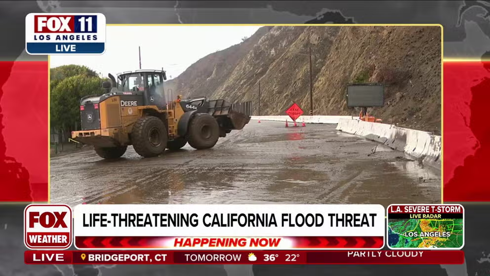
Heavy rainfall rates were too much for some areas around Los Angeles to handle as impassable roadways were encountered around the Palisades burn scar.
The California Department of Transportation (CALTRANS) said Thursday that a portion of the Pacific Coast Highway between Santa Monica and Malibu would be closed until further notice due to a significant risk of mudslides and debris flow.
Photos of the PCH show mudslides in areas previously burned by the Palisades and Eaton fires.
Officials in Santa Barbara County issued an Evacuation Warning for areas within and near the Lake Fire burn scar ahead of the rain event because of the potential for flash flooding, debris flows and mudslides. Residents in these areas were warned to be ready to leave at a moment’s notice.
The Santa Cruz Sheriff’s Office issued an order for some areas east of Watsonville, California, to evacuate immediately due to a threat from runoff just after 8 a.m. local time. Several roads were closed in the area due to flooding.
Voluntary evacuations were issued near burn scars in Orange County. The San Bernardino Sheriff’s Office issued a mandatory evacuation for communities impacted by the Line Fire.

(FOX Weather)
Many areas forecast to see up to 8 inches or more of rain include burn-scar areas in Southern California, including the recent deadly Palisades and Eaton fires.

(FOX Weather)
Areas including Santa Barbara, Los Angeles and Riverside face a Level 3 out of 4 flash flood risk through Friday.

(FOX Weather)
In addition to flooding concerns, this system will pack powerful winds with gusts up to 60 mph. Areas south of San Francisco could see higher winds, even gusts as strong as 80 mph, along coastal areas of the Big Sur and Marin Coastal Range.
A gust reached 71 mph at an elevated station in Acton, California, and power outages across the state have topped 40,000 so far.
Near Dublin, the California Highway Patrol reported two interstate closures due to flooding. Southbound Interstate 680 to Westbound Interstate 580 was closed due to water on the roadway.
In Hollywood, CALTRANS was hard at work removing debris from a clogged drain on a road that flooded.
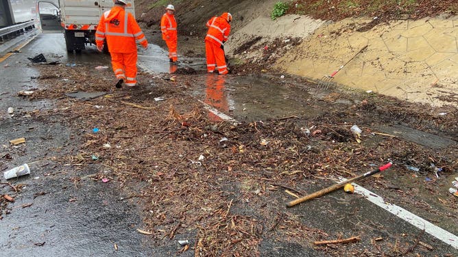
CALTRANS crews work to remove debris from a drain on a road in North Hollywood.
(@CaltransDist7/X / FOX Weather)
Las Vegas sees rain for first time since July
For the first time in 214 days, Las Vegas welcomed rainfall Thursday.
According to the FOX Forecast Center, it was the city’s second-longest dry streak on record.
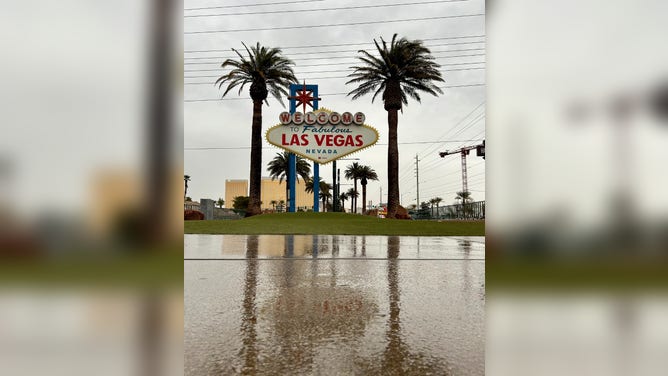
Rain falls in Las Vegas for the first time in seven months.
(@ClarkCountyNV/X)
Clark County took to X to celebrate the momentous occasion. “Time to save some water—turn off those outdoor sprinklers!” they said.
The area can expect roughly half an inch of rainfall on Thursday.
Feet of snow across Sierra, ice storm for Pacific Northwest
A winter storm has been unfolding at higher elevations since Wednesday night. A Winter Storm Warning is in place for the Sierra and White mountains through Friday night.
The forecast shows up to 7 feet of snow in the Sierra Nevada by the weekend.
Travel could be difficult next to impossible on Thursday with feet of snow and gusty winds up to 60 mph. The most dangerous travel conditions will happen during Thursday morning and evening commutes.
Strong winds could knock down trees.
Farther north, more than 1 million people are under ice storm warnings in Oregon.
DANGEROUS ICE STORM THREATENS OVER 1 MILLION IN PACIFIC NORTHWEST THURSDAY: ‘THIS HAS US CONCERNED’

(FOX Weather)
Across the West, the storm will wind down on Friday as it treks east, transforming into a winter storm for the eastern U.S.