According to NOAA, Kentucky averaged 28 tornadoes per year from 2000 to 2024. In 2024, the state had 57 tornadoes. We’ve had 44 in 2025 as of May 23.
LOUISVILLE, Ky. — On April 3, just past midnight, an EF-3 tornado touched down in an industrial/commercial area in Jeffersontown near Plantside Drive and Blankenbaker Parkway in Louisville. It then moved northeast over I-64 and the Gene Snyder Freeway to a residential area where dozens of homes were hit.
“It sounded like knives coming through the walls,” Annie Bolden said, who lives in the Beckley Hills neighborhood. Bolden was home with some family. They were all down in the basement but she wanted to stay up in the living room to watch the news.
“They had come up and told me I had seven minutes. So I said, ‘Oh, I believe it’s passed over.’ And I didn’t think anything about it until I heard the rumbling under my feet. Then I headed towards the stairs,” she said.
The National Weather Service (NWS) said the storm had 145 mph winds. It was the strongest storm to touch down in Jefferson County since 1996.
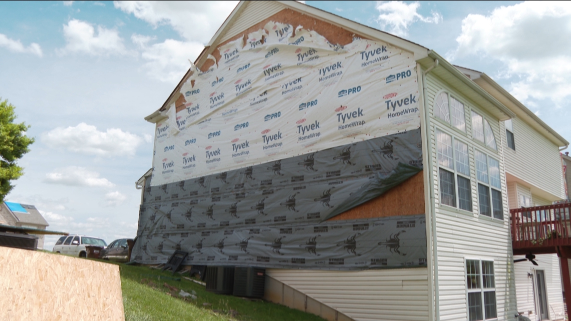
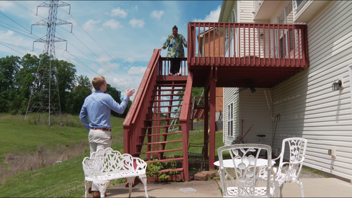
Bolden lost the siding on about 40% of her house. The stairs leading from her backyard up to her back porch got twisted away from the porch and they’re no longer safe to walk on. She has had an insurance adjuster out but they haven’t given her an estimate yet.
Kentucky is seeing a sharp increase in the number of tornadoes every year. According to NOAA, the National Oceanic and Atmospheric Administration, Kentucky averaged 28 tornadoes per year from 2000 – 2024.
The last two years are whipping those averages. There were 57 tornadoes in 2024, and from the start of 2025 until May 23, there’s been 44 tornadoes, according to the NWS and the Kentucky Climate Center.
“Climate change and warming is causing one thing in particular,” Gabriel Filippelli said, an earth sciences professor at Indiana University. “Which is that warmer air –which we can measure is getting warmer– warmer air holds more water vapor. So let’s take a normal hurricane or a normal storm; category 3 let’s say. That hurricane, which previously might have caused $1 billion worth of damage now causes $3 billion of damage. Because it’s not just the wind, it’s the sheer amount of flooding water.”
Filippelli said even for inland storms like tornadoes, the rising air temperatures means more humidity, more storm fuel and more damage.
Shane Holinde, outreach manager for Kentucky Mesonet and Kentucky Climate Center at Western Kentucky University, said there definitely has been an increase in tornadoes, but it’s also partly due to better technology to track them.
“One thing to keep in mind is that many years ago we didn’t have doppler radar,” Holinde said. “We didn’t have dual polarization radar, which made for correlation coefficient which is a product that allows for debris detection. That didn’t come out until 2013.”
Holide also pointed out that of the 44 tornadoes in the Commonwealth this year, only eight have been EF-2 or stronger.
Both men talked about a national phenomena that experts and insurance companies are publicizing in 2025; that “tornado alley” is shifting north and eastward.

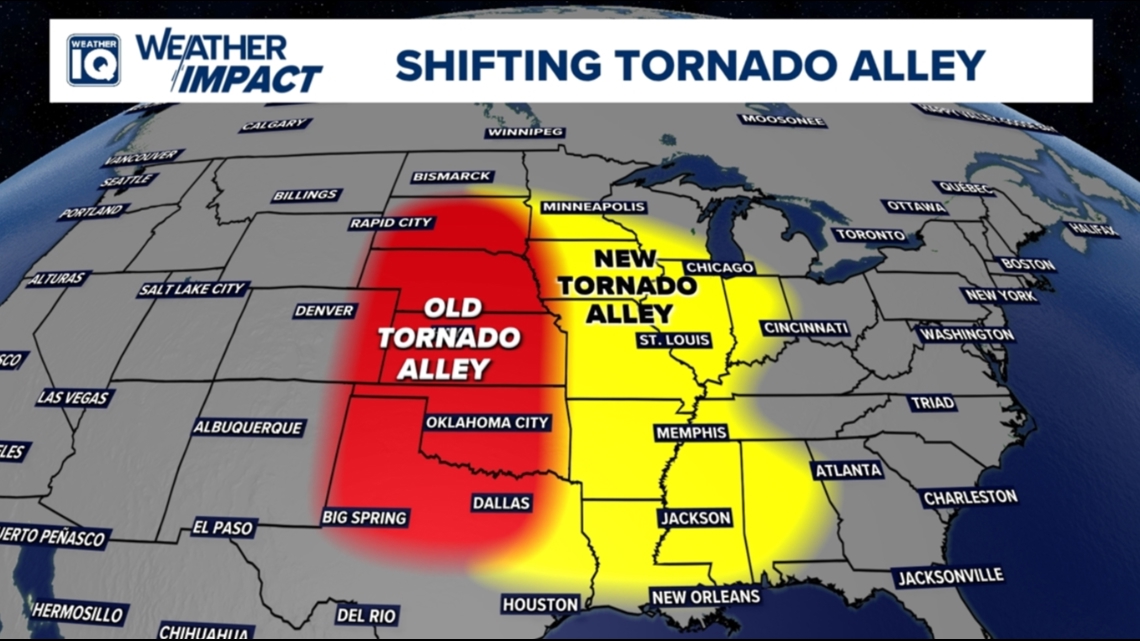
Filippelli said this is because the sweet spot for tornadoes is the transition from spring to summer, and the upper south and Midwest are seeing warmer springs and faster starts to summer.
“The storm tracks that maybe would have stayed a little bit south of us, because we’d be in the last throws of winter transition,” he said. “Well, we’re already heading into some conditions that are almost summer-like.”
Bolden said while the increase in tornadoes isn’t fun to talk about, she feels people need to talk about it.
“That’s scary; and I don’t think I can understand how people don’t believe it,” Bolden said.
She hoped for the future of her grandson, we can reverse this trend.