MINNEAPOLIS (FOX 9) – Strong storms are rolling into the Twin Cities metro, bringing heavy rain and hail.
Here are live updates for storms pushing through the metro:
5:33 p.m. – Severe thunderstorm watch
A severe thunderstorm watch has been issued for a large portion of southern Minnesota, including in the Twin Cities, and Wisconsin until 11 p.m.
4:55 p.m. – Severe thunderstorm warnings in Twin Cities
Severe thunderstorm warnings have been issued for Carver, Dakota, Hennepin and Scott Counties until 5:30 p.m.
A severe thunderstorm warning has also been issued for Pierce and Washington Counties until 5:45 p.m.
Hail has been reported in Woodbury and Cottage, and on the other side of the metro in Waconia.
4:30 p.m. – Flash flood warning in Twin Cities
A flash flood warning is in place for Hennepin and Ramsey Counties until 6:15 p.m.
What the storms could bring
Local perspective:
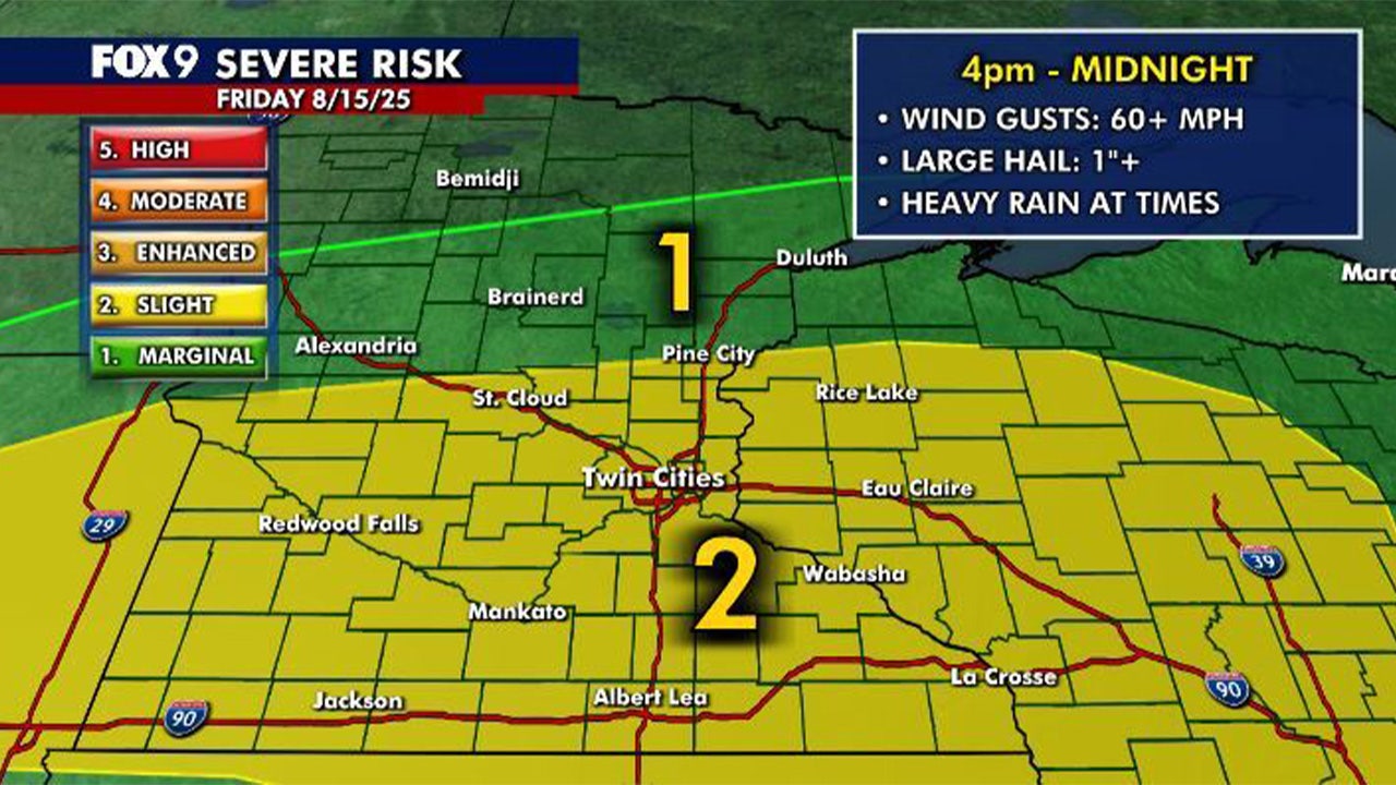
Several rounds of storms are possible over the coming days, including for Friday. The southern half of the state is under a Level 2 risk for severe weather, with wind being the primary threat. Large hail, 60+ mph wind gusts and heavy rain are possible with these storms.
READ MORE: Heavy rain may come in parts of Minnesota over the weekend
A cold front will move into the area on Friday and stall out. Strong to severe storms are likely to develop along that boundary later in the afternoon and evening, and continue overnight into Saturday morning, though they should likely weaken.
The boundary will serve as a focal point for humidity and several waves of potential heavy rain through the weekend. A broad area of 1–2 inches of rain is expected, though localized rain totals of 3–6 inches are possible. The heavy rain could lead to occasional flooding concerns through the weekend.

The severe weather risk map for Aug. 15, 2025. (FOX 9)
Hot, steamy Friday
The forecast:
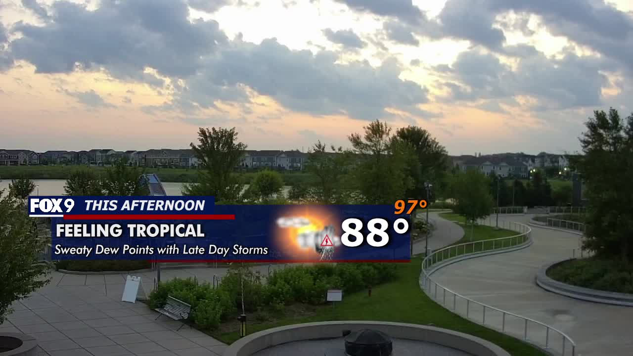
Ahead of the storms, it will be hot and steamy with dew points in the 70s and temperatures in the mid to upper 80s. The Twin Cities daytime high is 88 degrees, with a heat index value in the mid to upper 90s.
Overnight, temperatures dip into the 50s and 60s for northern Minnesota, but stay warm and muggy in the 70s for the southern half of the state.
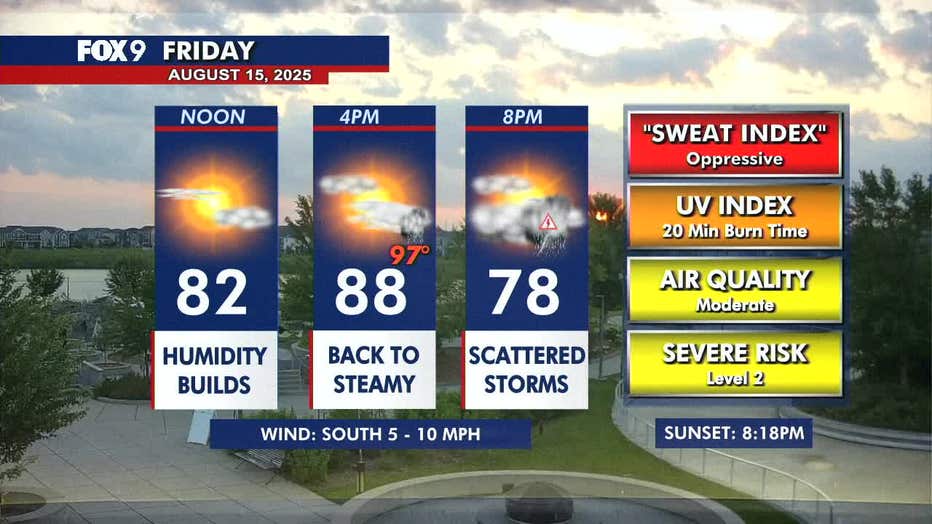
Day planner Aug. 15, 2025. (FOX 9)
Extended MN weather forecast
What’s next:
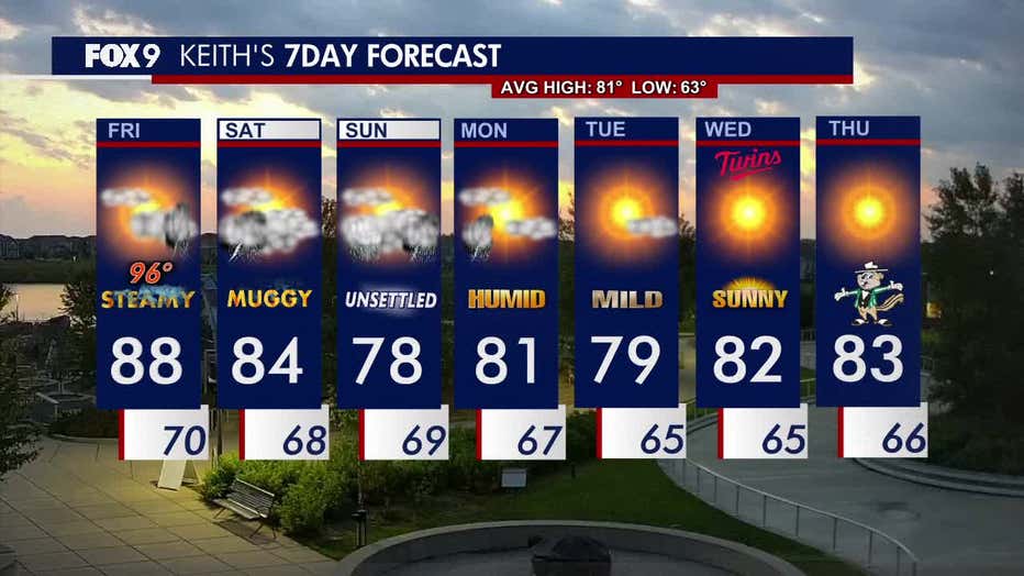
Saturday begins with morning rain and thunder before skies turn mostly cloudy. A stray afternoon rumble can’t be ruled out, but the afternoon will be mostly muggy and dry with highs in the 80s.
Another round of showers and storms could roll through Saturday night and linger for parts of Sunday. The end of the weekend will be slightly cooler with highs in the 70s.
Monday morning could see some additional showers before clearing out and ending the several-day stretch of rainy weather. The week ahead looks much calmer and drier with seasonable temperatures in the lower 80s.
Here’s a look at the seven-day forecast: