
Steamy, stormy weather was in the forecast for the Chicago area Tuesday, with temperatures as high as 90 degrees, thunderstorm chances and an air quality alert for some, the NBC 5 Storm Team said.
And while the temperatures will cool slightly midweek, the risk of strong-to-severe storms looms Wednesday, NBC 5 Storm Team Meteorologist Alicia Roman said, with heavy downpours, gusty damaging winds, small hail and even a brief tornado.
“We’ll have to watch that,” Roman said, of Wednesday’s severe weather outlook.
Tuesday morning started out warm and dry, with temperatures already in the mid 70s. Those temperatures will rise to the mid 80s and low 90s by the late afternoon, Roman said, with muggy conditions creating a “feels like” temperature in the mid 90s.
In parts of northern Indiana, an air quality alert was in effect due until midnight due to elevated levels of ozone, the National Weather Service said.
By 3 p.m., storm chances will increase, beginning in counties to the far west.
“Any storm that does develop could be a little gusty,” Roman said, “maybe with some small hail.”
After about 4 p.m., Chicago’s northern counties could see showers and storms, with winds up to 40 miles per hour.
As part of the stormy weather expected Tuesday afternoon, the storm prediction center placed areas to the north and west under a low-end, “marginal” risk of severe weather, which ranks as level one of five. Areas to the south could remain mostly dry.
“Some of these storms may be strong to severe, with damaging winds as the main severe weather threat,” the National Weather Service warned, addition that additional storm clusters could redevelop overnight. “These storms may produce torrential downpours, which could lead to localized flooding.”
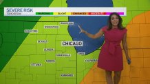
Some showers and storms could linger into Wednesday morning, Roman said, with storm chances returning in the late afternoon, around 3 p.m. Roman said. At that time, the entire Chicago area will be at an upgraded, “slight” risk of severe weather, which ranks as level three of five.
According to Roman, the main threats Wednesday’s with storms would be gusty damaging winds, small hail, heavy downpours and the possibility of a brief tornado.
The storms come as a cold front moves in, bringing temperatures back down into the low 80s.
“Strong to severe thunderstorms are possible, especially during the afternoon hours,” the NWS said of Wednesday’s forecast. “Damaging winds, large hail and brief tornadoes are possible, in addition to locally heavy rainfall.”
The NWS went on to say that isolated, strong storms were possible across southeast Wisconsin Thursday afternoon and evening, with some storms clipping far northeast Illinois near the border.
Thursday and Friday, temperatures will remain in the 80s, Roman said, with summer officially beginning Friday.
Saturday and Sunday, warm and muggy conditions return, with highs in the low to mid 90s.
“Maybe feeling like 100 degrees over the weekend,” Roman said.
